
Although ArcGIS allows to
bring the Bing maps and Esri images as base layers in ArcMap, still sometimes
we rely on google images because of their better accuracy and their frequent
update. Some of us using openlayers plugin in QGIS
to access the google maps as a base map. This
tutorial shows you to how quickly you can add the google maps, google hybrid
images and open street maps etc. to the ArcMap for testing purposes.
Portable basemap server
PBS is an open source
WPF application which can be used to access the WMTS basemap service inside ArcGIS.
Steps


Steps
2.Open the Portable Basemap Server folder and
right click the PortableBasemapServer.exe

3.Select the GoogleMapsImagery or desired
one in the Data Source Type drop down menu.

4. Then click the Start New Service button.

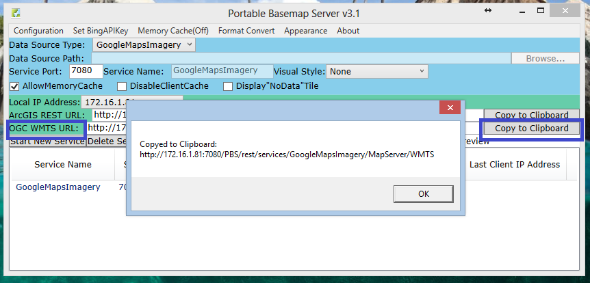
5.Copy the OGC WMTS URL by clicking the Copy to
Clipboard. Don't stop the PBS application, just minimize that.
6. Next open the Arcmap.
7.Open the Catalog and then click the Add WMTS server in
GIS Servers.

8.Paste the Copied URL here in URL text box. Click Get Layers and click OK.

9.Next, right click the added WMTS Server and
click the connect option.

10.Now it’s time to import the base map layer. You
can drag down the GoogleMapsImagery from the Catalog to ArcMap Data View
or you can simply add through the Add Data option.

Interesting tool! Do you know if it coincides with Google's terms of use? I know that we've had issues accessing the imagery, not using their mapping interfaces.
ReplyDeleteI don't think you are having any legal issues as long as you are using the their mapping service as a web interface
DeleteHow can I add multiple services at a time?
ReplyDelete